简介:ToimprovethecurrentGISfunctionsindescribinggeographicobjectswithfuzziness,thispaperbeginswithadiscussiononthedistancemeasureofspatialobjectsbasedonthetheoryofsetsandanintroductionofdilationanderosionoperators.Undertheassumptionthatchangesofattributesinageographicregionaregradual,theanalyticexpressionsforthefuzzyobjectsofpoints,linesandareas,andthedescriptionoftheirformalstructuresarepresented.Theanalyticmodelofgeographicobjectsbymeansoffuzzyfieldsisdeveloped.Wehaveshownthatthe9-intersectionmodelproposedbyEgenhoferandFranzosa(1991)isaspecialcaseofthemodelpresentedinthepaper.
简介:Thispaperpresentsanewfuzzymultiplecriteria(bothqualitativeandquantitative)decision-making(MCDM)methodbasedonfuzzyrelationaldegreeanalysis.Theconceptsoffuzzysettheoryareusedtoconstructaweightedsuitabilitydecisionmatrixtoevaluatetheweightedsuitabilityofdifferentalternativesversusvariouscriteria.Thepositiveidealsolutionandnegativeidealsolutionarethenobtainedbyusingamethodofrankingfuzzynumbers,andthefuzzyrelationaldegreesofdifferentalternativesversuspositiveidealsolutionandnegativeidealsolutionarecalculatedbyusingtheproposedarithmetic.Finally,therelativerelationaldegreesofvariousalternativesversuspositiveidealsolutionarerankedtodeterminethebestalternative.Anumericalexampleisprovidedtoillustratetheproposedmethodattheendofthispaper.

客服QQ:30444492琼网文【2021】1550-113号
增值电信业务经营许可证:琼B2-20210322
出版物经营许可证:新出发龙华出字第(2021)009号
广播电视节目制作经营许可证:(琼)字第00779号
版权所有 ©2002-2024 期刊网(www.qikanchina.com) 琼ICP备2021005105号


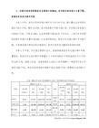 三差" title="三数"与"三差">


 三数"" title="趣说"三数"">


")